


OPINION

From the journeys of Indian explorers into Tibet to China’s proposed mega-dam on the Yarlung Tsangpo, the history of the eastern Himalayas has much to tell India about its northern frontier, writes Saurabh Chauhan.*
India’s debate on China is usually dominated by the Line of Actual Control, military infrastructure and the possibility of another confrontation along the Himalayan frontier. These are important concerns, but there is a longer history behind India’s northern security questions. Much of it begins with Tibet.
For centuries, Tibet was connected to the Indian subcontinent through trade, pilgrimage and religious exchanges. Mountain passes linked communities on both sides of the Himalayas. Monks travelled between monasteries, traders carried goods across difficult routes and rivers flowing from the Tibetan Plateau sustained settlements further south. These connections existed long before the modern India-China boundary dispute.
The political transformation of Tibet in the twentieth century changed this geography. It also changed India’s relationship with its northern neighbour. Today, with China constructing a massive hydropower project on the lower reaches of the Yarlung Tsangpo, the river has become another point of concern for New Delhi.
The proposed project raises questions about water security, the availability of hydrological information and the future of communities living along the Brahmaputra. India’s response, however, cannot be limited to building infrastructure of its own. There is a history here worth revisiting and there are people whose lives will be affected by decisions taken in Beijing and New Delhi.
The explorers who mapped Tibet
India’s relationship with Tibet did not begin with the boundary dispute. Trade, religious exchanges and travel connected the two regions through Ladakh, Sikkim, Bhutan and the eastern Himalayas. These routes were familiar to local communities long before they appeared on modern maps.
The British period brought a more organised effort to map Tibet. During the nineteenth century, British India was concerned about Russian expansion in Central Asia and the security of its northern approaches. Tibet became an important part of what was later called the Great Game.
But the history of exploration is not simply a story of British officers entering an unknown land. Indian explorers made some of the most important contributions to geographical knowledge of the Tibetan Plateau. Their work is often remembered through the reports of the colonial administration rather than through their own achievements.
One of the best-known figures was Nain Singh Rawat, a Kumaoni explorer trained by the Survey of India. His journeys into Tibet were remarkable, considering the conditions under which he travelled. Disguised as a Buddhist pilgrim, he recorded distances, altitudes, routes and geographical observations using methods that allowed him to survey the landscape without attracting attention.
His journey to Lhasa in 1865–66 was particularly important. He also explored parts of the upper Brahmaputra region. T. G. Montgomerie’s report, published in the Journal of the Royal Geographical Society in 1868, records the route survey made by the explorer from Nepal to Lhasa and through the upper valley of the Brahmaputra. Its accompanying map remains an interesting historical document.
Nain Singh should not be remembered merely as an assistant to British surveyors. His ability to travel through Tibet and record its geography made a significant contribution to the understanding of the Himalayas. His story also raises a question about how India remembers those who helped document its own northern frontier.
Another important figure was Sarat Chandra Das, a Bengali scholar and explorer who travelled to Tibet in the late nineteenth century. His Narrative of a Journey to Lhasa in 1881–82, published in 1885, is an important account of Tibetan society, institutions and geography. His later work, Journey to Lhasa and Central Tibet, also remains useful to historians.
Das was not simply interested in routes and mountains. His writings offer glimpses of the society through which he travelled. They provide material on Tibetan religious institutions, customs and intellectual life, something that is often missing from accounts concerned mainly with imperial geography.
There was, of course, a colonial purpose behind much of this exploration. The British wanted information that could serve administrative and military interests. That context should not be ignored. But neither should the contribution of the Indian explorers who undertook these journeys.
Following the Tsangpo
The history of the Yarlung Tsangpo is particularly interesting because its connection with the Brahmaputra was not immediately established by European surveyors.
The river flows eastwards across Tibet before making a dramatic turn around the Namcha Barwa massif in the eastern Himalayas. It then enters Arunachal Pradesh as the Siang and flows through Assam as the Brahmaputra. Further downstream, it enters Bangladesh, where the main river is known as the Jamuna.
For a long time, the course of the river through the eastern Himalayan gorges remained uncertain. Explorers wanted to establish whether the Tsangpo continued into Assam and how it crossed the mountain system.

One of the most remarkable attempts was made by Kinthup, a Lepcha explorer who worked with the Survey of India. He was sent into Tibet to investigate the river. His mission involved releasing marked logs into the water at an agreed time so that observers downstream could identify them and establish the river’s course.
The expedition went badly wrong. Kinthup faced deception, captivity and considerable hardship. His observations were not immediately accepted and his contribution received recognition much later.
The next important stage came in 1913, when Frederick Marshman Bailey and Henry Morshead undertook an exploration of the Tsangpo gorge. Bailey was a British military officer and political officer with considerable knowledge of Tibet. Morshead was a Survey of India officer. Their journey helped clarify the geography of a region that had remained difficult for outside surveyors to access.
Bailey published his account, Exploration on the Tsang-Po or Upper Brahmaputra, in the Scottish Geographical Magazine in 1914. Morshead’s contribution to the expedition is recorded in later historical accounts, including Michael Ward’s work on the exploration of the river.
Ward’s article, The Exploration of the Tsangpo River and its Mountains, published in the Alpine Journal in 2000, is a useful starting point for understanding these journeys. More recently, historian Thomas Simpson’s 2024 study, Find the River: Discovering the Tsangpo-Brahmaputra in the Age of Empire, has examined the relationship between geographical exploration, imperial ambitions and local knowledge.
That last point deserves attention. These explorers did not travel through an empty landscape. They depended on Tibetan routes, local guides, traders and people who already knew the terrain. Pilgrimage networks and knowledge passed down through generations were essential to their journeys. The history of the river cannot be told only through the records of colonial surveyors.
There is a lesson here for India. Understanding the Himalayan frontier has never depended on maps and military surveys alone. Local knowledge has always mattered. It should matter just as much when India considers the future of its rivers.
When Tibet changed
The political history of Tibet between 1914 and 1950 is important to understanding the boundary dispute between India and China.
The Simla Convention of 1914 brought together representatives of British India, Tibet and China. The negotiations dealt with Tibet’s political position and the boundary between British India and Tibet. The McMahon Line emerged from the discussions between British India and the Tibetan representative, Lonchen Shatra.
The Chinese representative initially participated in the negotiations but did not sign the final convention. Britain and Tibet subsequently signed a separate agreement. China rejected the arrangement and its objections to the McMahon Line remain central to the eastern sector of the India-China boundary dispute.
For much of the period that followed, the Tibetan government in Lhasa exercised substantial de facto autonomy, although Tibet’s international status remained contested. British India maintained trade agencies at Gyantse, Yatung and Gartok. A British mission was established in Lhasa in 1936. These arrangements continued into the final years of British rule in India.
When India became independent in 1947, it inherited a complicated relationship with Tibet. The Indian government continued to maintain trade and diplomatic contacts with Lhasa, but the political circumstances were changing rapidly.
In 1950, the People’s Liberation Army entered eastern Tibet and defeated Tibetan forces at Chamdo. The following year, the Seventeen-Point Agreement was signed between representatives of the People’s Republic of China and the Tibetan government. It formalised Beijing’s control over Tibet, although the circumstances surrounding the negotiations and the agreement remain disputed in historical accounts.
India’s relationship with Tibet changed accordingly. The 1954 Agreement on Trade and Intercourse between the Tibet Region of China and India reflected the new political reality. It also introduced the Five Principles of Peaceful Coexistence, commonly known as Panchsheel, into the relationship between the two countries.
The deterioration of India-China relations in the years that followed culminated in the 1962 war. The boundary dispute remained unresolved, but the political transformation of Tibet had already altered India’s strategic position along the Himalayas.
It is worth remembering this history because the question of Tibet is often discussed in India only in the context of China. Tibet has its own political history, people, language and cultural identity. Its significance to India cannot be reduced to its usefulness in a territorial dispute.
China’s dam and the Brahmaputra
The present water debate is another chapter in this longer relationship. In December 2024, China approved a major hydropower project on the lower reaches of the Yarlung Tsangpo. Construction formally began on July 19, 2025, when Chinese Premier Li Qiang attended the groundbreaking ceremony in Nyingchi.
According to Chinese state media, the project will consist of five cascade hydropower stations, with an estimated investment of around 1.2 trillion yuan. Its planned capacity is approximately 60,000 MW, making it one of the largest hydropower developments ever proposed.
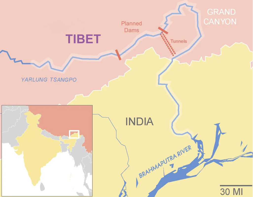
The location explains much of the concern in India. The Yarlung Tsangpo makes its great bend around the eastern Himalayas before entering Arunachal Pradesh as the Siang. It then flows through Assam and into Bangladesh.
The river is not important only because it crosses international boundaries. It supports agriculture, fisheries, transport and local economies. Its annual cycle is also closely tied to monsoon rainfall, snowmelt, steep Himalayan catchments and the flow of numerous tributaries.
The Brahmaputra is among the world’s most sediment-rich river systems. Sediment carried from the Himalayas helps shape its channels and floodplains. Research published in the Journal of Geophysical Research: Earth Surface has examined the seasonal variation in sediment sources and transport across the basin. Much of the sediment movement takes place during the monsoon.
This matters because a large hydropower project does not affect a river only through the amount of water it releases. Its design and operation can influence sediment movement, seasonal flows and the surrounding river ecosystem.
At the same time, it would be wrong to assume that a dam automatically allows an upstream country to switch off a river. The actual downstream consequences depend on the project’s design, storage capacity, operating rules, water releases and the natural flow of the river. There is a difference between a possible risk and an established impact.
China has maintained that the project is intended to generate clean electricity and support development in Tibet. Its official announcements have also referred to the project’s contribution to China’s wider energy transition. But information available publicly about its detailed design, environmental consequences and operating arrangements remains limited.
India has legitimate reasons to seek greater transparency. It needs reliable information about the project’s construction, water management and possible downstream effects. This is not an unreasonable demand from a country that shares the river system.
There is already a history of hydrological cooperation between the two countries. India and China signed a memorandum of understanding in 2002 for the provision of flood-season hydrological information on the Brahmaputra. It was renewed in 2008, 2013 and 2018.
However, the Ministry of Jal Shakti’s annual reporting records that the Brahmaputra agreement expired on June 5, 2023 and that its renewal was being pursued through diplomatic channels. The suspension of regular data provision after its expiry is a serious concern. Flood forecasting becomes more difficult when information from upstream monitoring stations is unavailable.
India should continue to press China for regular data-sharing, advance notification of unusual water releases and access to relevant environmental information. It also needs to strengthen its own monitoring capacity through river gauges, satellite observation, flood forecasting and independent scientific research.
Bangladesh should be part of this conversation. The country receives the Brahmaputra downstream as the Jamuna and depends on the river for agriculture, livelihoods and flood management. India’s discussions with Bangladesh on the future of the river should go beyond occasional diplomatic exchanges. A more regular approach to flood forecasting, scientific research and basin-level information would benefit both countries.
The Siang dispute
India’s proposed response has increasingly centred on the Siang Upper Multipurpose Project in Arunachal Pradesh, planned at 11,200 MW.
The project is being considered partly in the context of China’s upstream hydropower development. An Indian dam, according to its supporters, could help provide additional water-management and flood-moderation capacity while strengthening the country’s position in the event of major changes to upstream flows.
But there is an important qualification. The Siang project remains at the preliminary feasibility stage. Its technical capabilities and ability to respond to any possible upstream intervention cannot be treated as established facts.
Arunachal Pradesh Chief Minister Pema Khandu said in September 2026 that the government did not intend to take the project beyond the feasibility stage without examining the technical findings. The preliminary feasibility report, he said, would help determine whether and how the project could be developed.
The debate in the Siang Valley, however, is about more than engineering. Sections of the Adi community have strongly opposed the proposed project. Their concerns include the possible submergence of villages, agricultural land, forests and places connected to their history and cultural practices.
The Adi institution of the kebang, a traditional community council, plays an important role in local decision-making. In August 2025, a Bogum Bokang Kebang, a wider gathering of Adi representatives, was held at Geku to oppose the proposed dam and the pre-feasibility exercise.
For the Adi people, the Siang is not simply a source of electricity. Their relationship with the river is connected to ancestral memory, agriculture, land and cultural identity. The river is often associated with Ane Siang, while the land itself carries religious and ancestral significance.
The scale of the possible displacement is also a matter of concern. The Siang Indigenous Farmers’ Forum has estimated that 27 villages could be completely submerged, with another 40 to 50 affected. These figures need to be examined through independent surveys, but they cannot be dismissed.
The protests intensified in October 2026. Reuters reported on October 27 that additional security personnel had been deployed in the valley after clashes between protesters and police. At least 21 people had been arrested, according to the report. The protests have raised difficult questions about the relationship between national security, development and the rights of indigenous communities.
The government has argued that the project is strategically important and that the present exercise is intended to establish its feasibility. That position also needs to be heard. India cannot ignore a major upstream project being constructed close to its border.
But there is a question New Delhi must answer: who bears the cost of a project being justified in the name of national security?
The concerns of the Adi people should not be treated as an obstacle to India’s strategic interests. They are part of those interests. The security of Arunachal Pradesh cannot be measured only through military presence and infrastructure. It also depends on whether people living in the region trust the government and believe their concerns are being taken seriously.
A project of this scale requires independent geological, environmental and social assessments. The region is seismically active. Landslides, sedimentation, earthquakes and changing river flows all need to be examined before any final decision is made.
It is equally important that consultation is not reduced to a series of official meetings. Communities need access to the findings, a clear understanding of the possible consequences and a meaningful role in decisions affecting their land.
This does not mean that the project must automatically be abandoned. It means that a preliminary feasibility exercise should not become an argument for construction before the scientific and social questions have been answered.
The people along the river
There is another dimension to the Brahmaputra debate that deserves more attention. The river connects Tibet, Arunachal Pradesh, Assam and Bangladesh, but the people living along it are rarely part of discussions conducted at the national level.
In Tibet, the Yarlung Tsangpo has shaped settlement patterns and agriculture for centuries. In Arunachal Pradesh, the Siang is closely connected to the lives of communities along its banks. In Assam, the Brahmaputra is central to agriculture, transport and the state’s economy. In Bangladesh, the Jamuna supports a large population living with the opportunities and dangers of a major river system.
The river also carries enormous quantities of sediment. Its channels shift, islands appear and disappear and floods reshape settlements and agricultural land. Any major intervention upstream needs to be understood in the context of this entire basin.
A 2025 study by Dongmei Zhao and colleagues, published in Water Resources Research, examined the effects of existing dams on flow and sediment regimes on the Tibetan Plateau, using the Yarlung Tsangpo as a case study. The research is relevant to the wider debate, although it should not be treated as a direct prediction of what China’s new project will do.
India needs more independent research on these questions. Universities, hydrologists, environmental scientists and local institutions should be involved. The country should also work more closely with Bangladesh on river monitoring and the exchange of scientific information.
There is a historical reason for taking local knowledge seriously. The early explorers who travelled through Tibet depended on people who knew the mountains and rivers. Their knowledge helped establish geographical facts that were not available through maps or official records alone.
Today, India faces a different challenge. It is no longer trying to establish where the river flows. It needs to understand how changes to the river might affect the people who depend on it.
A frontier beyond the border
The journeys of Nain Singh Rawat, Sarat Chandra Das, Kinthup, Bailey and Morshead tell us something about the importance India once attached to understanding Tibet and the eastern Himalayas. Their work belongs to a different political age, but the geographical questions they explored remain relevant.
There is also a part of this history that India should recover. The exploration of Tibet and the Tsangpo was not simply the achievement of colonial surveyors. Indian explorers, Tibetan guides, local traders and communities along the river all contributed to the knowledge that made these journeys possible.
The present challenge is more complicated. China is building a major hydropower project on the Yarlung Tsangpo, while India is considering a large project of its own on the Siang. Both countries have development and energy interests. Both also have responsibilities towards the people and ecosystems affected by decisions taken upstream.
India should demand transparency from China and strengthen its own scientific and diplomatic capacity. It should also avoid treating the Siang project as a strategic answer before its feasibility and consequences are properly understood.
Most importantly, the future of the Siang cannot be decided only in Delhi. The future of the Yarlung Tsangpo cannot be discussed only in Beijing. The communities living along these rivers have a stake in decisions that will affect their homes, livelihoods and environment for generations.
India’s interest in Tibet is not a new strategic invention. It has a long historical foundation, shaped by geography, trade, religion and the political history of the Himalayas. The present water debate has brought that relationship back into focus.
—
* Saurabh Chauhan is an independent journalist and researcher whose interests include Tibetan history, Tibetan Buddhism, Himalayan affairs and India-China relations. His work explores Tibet’s historical and contemporary significance, with particular attention to the Tibetan diaspora, the future of Tibetans in exile, and the intersection of culture, politics and technology. He is also working on a book titled ‘Prayer Wheels in the Cloud’.